

Datalink Systems has been designing software for fifteen years. Our latest development RediTrac is compatible with Marcotte Smart Systems for Ready Mix producers.
Knelsen Sand and Gravel, Calgary, Alberta is the first company to adopt RediTrac for use with the Kenwood Mobile Radios installed in their concrete delivery trucks. Live status updates inform the dispatchers on the status and location of every truck on a minute by minute basis, ensuring an efficient flow of concrete to every job-site.
Each status update is transmitted over the wireless network to a DataGate processing hub, normally installed in the Ready Mix company's computer which processes the data and forwards it to the Marcotte WebServer which routes it to the Marcotte Operations system at the company’s dispatch desk where the user will have visual information of each trucks status on job.


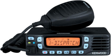
The MT-660 connects directly to the data port on the rear of Kenwood NEXEDGE mobile radios. This allows both voice and data to be sent over the Kenwood radio network reducing monthly operating costs.
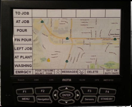
The MT-660 provides extensive monitoring of concrete truck statuses and functions including two-way text messaging, live map route navigation. Never have a driver get lost enroute.
RediTrac can also be used in a basic mode, using only the keypad of Kenwood NEXEDGE mobile radios.
The driver scrolls, selects and sends the current status "to job" "at job" "pouring" "pour finished" "left job" "at plant" "washing". GPS location is sent with each message and also every 5 minutes. The dispatch desk can also poll the truck for an immediate GPS update.
The RediTrac system will work over Kenwood NEXEDGE digital trunked and older analog networks using Fleetsync. RediTrac will also work over GSM cellular networks globally using GPRS data services.
GSM GPRS data service can also be an option for Kenwood LMR Dealers where data transmissions are interfering with voice transmissions. GPRS data services can be resold by Kenwood dealers, providing an additional monthly revenue stream

iMDT 660 is a new model of MOTIA MDT (on-board computer) lineup having 7 Inch LCD, Samsung S3C2450 processor and more rugged design for Fleet Management Service provider. And, this new product has more stable power management features through dual super capacitors/surge protection circuit in preparation for sudden power loss, drop or surge in Truck or heavy equipments.
Total 7 x RS232 serial port :
USB ports
During more than 14 years, Datalink has been creating advanced wireless communication solutions, with an emphasis on remote goods tracking and SCADA applications.
Our seasoned team of Engineers has developed a wide variety of solutions for diverse applications, including:
Below is a list of some of our past projects. As you will be able to see, it doesn't matter where you are, or what your wireless data communication needs are: Datalink has the right solution for you!
CTS Canada (Oil and Gas Production) Specialized worker safety communications tracking of cablevision service vehicles
Time Warner Cable (Hawaii) GPS tracking of cable service vehicles
Western Australia Government Tracking of vehicles and other assets
Click here for details
Harris County (Houston, Texas)AVL tracking and messaging system for ambulances
Northern Canada GPS tracking of trucks on lake ice roads
Long Island Railroad, New York. GPS based automatic reporting of trains arriving at each station
San Bernardino Sheriffs Dept, California GPS based emergency tracking and messaging over geostationary satellite
Carseg SA Colombia Specialized tracking system for LoJack concessionaire in Colombia
Salvation Army (Canada) GPS tracking of donation pick-up trucks
Guayaquil, Ecuador Lo-Jack development for unmanned city wide tracking stations
Click here for details
USA Nuclear Waste Trains. Geostationary satellite-based security tracking of "extremely hazardous" train cargo. Click here for details
GPS Solutions Surinam Tracker i50 processing data from trucks in open pit mining sites
Fisheries Canada Pilot project for GPS tracking and messaging for deep sea fishing vessels over geostationary satellite
SCADA Geostationary satellite communications for oil field control in the Arctic Circle and Gulf of Mexico
Caracas, Venezuela GPS tracking of bullion security vans
Guayaquil, Ecuador GPS logging of garbage collection truck routes and times
CarSearch Nigeria GPS tracking and two-way messaging for trucking fleet
Globalstar Panama/Venezuela Tracking of fishing vessels
Metro St. Louis Sewer District Field record management and dispatching over CDPD
Manteca Police Department, California. Emergency officer-down security system.
Click here for details
Nuevo Leon State Police, Mexico. Tracker GPS logging of state police patrol vehicles
Spacechecker (Europe) Tracking of trucks, ships and barges across Western Europe
U.S. Customs Special communications systems
Canada Customs Special communications systems
U.S. Dept of Justice Special communications systems Click here for details
CarSearch. Nigeria Satellite security tracking for long haul trucks
Schneiders Truck Lines. Canada AVL tracking and messaging over satellite and CDPD (dual mode)
North West Pipelines SCADA remote control and monitoring over Globalstar
Nomis Seismographs Remote control and monitoring over Globalstar
All-West (Canada) Lone-worker monitoring and data communications over Globalstar
Haiti Fleet GPS tracking
AST Australia GPS tracking of forest fire fighting aircraft
AST United Kingdom GPS tracking of fishing boats for government fishing compliance
Datalink Systems developed an officer-down personal emergency unit to be worn by police officers. When a panic button was pressed, the signal was transmitted to the patrol car where a Datalink black-box unit processed the data and re-transmitted over CDPD to a DataGate located in the police department's server. DataGate would re-transmit the data to a number of PCs on the LAN.
The system was designed by Datalink and became active in 2001.
Datalink Systems was contracted by the U.S. Deptartment of Justice to develop a variant of DataGate for secure tracking of field operatives in Central America, providing fast emergency response. Personal communication devices worn by the field operatives would link to their vehicle where the data was re-transmitted over MSV-MSAT1 to a base DataGate. The DataGate would process the data and re-transmit to selected pagers.
The system was designed by Datalink and became active in 2002.
Datalink Systems developed software to allow tracking of fire fighting aircraft operated by the Department of Environment and Conservation of the Western Australian Government. This entailed processing data transmitted by Inmarsat D+ satellite terminals on aircraft, then writing the data to an Oracle database and further to detailed map screens.
DataGate IP routing software installed in one of DEC's servers controlled the flow and distribution of data.
Datalink's partner in this project was ASTA (Applied Satellite Technologies Australia).
Datalink Systems developed a city wide monitoring and data relay system that would allow LoJack http://www.lojack.com/car/pages/car-works.aspx equipped vehicles to be located quickly when stolen.
CARSEG (LoJack franchisee) placed a number of monitors on roof tops around the city, with each site equipped with a TAIT T2010 UHF transceiver and Datalink's intelligent modem. Data packets were relayed via other sites across the city to the base office where a DataGate processed the data and displayed it on a screen. Receiver signal triangulation located the stolen vehicle in a specific neighborhood followed by a tracker car and Police being dispatched to recover the vehicle.
The system was designed by Datalink and became active in 2000.
Datalink's partner in this project was CARSEG, S.A. based in Guayaquil, Ecuador.
Datalink Systems was contracted to develop and supply a highly secure satellite based tracking and emergency alert system to track trains moving nuclear waste across the USA. A satellite terminal located on the train transmitted the data over the MSV MSAT1 satellite to the ground station, where it was them re-transmitted over MSAT1 to a satellite receiver located on the monitoring company's building. This data path was considered more secure than any terrestrial alternative.
The system was designed by Datalink and became active in 2002.
Datalink does not provide "on-site" installation service. That is left to the local dealer or the company's own maintenance and service personnel. Datalink will provide extensive "on-line" training and support. Typically Datalink support engineers are granted temporary remote access to the company's computers in order to install the required software. This is followed by training the staff responsible for dispatching control and operation.
On going support and software updates are provided by Datalink and included in the original purchase


1471, Lionel Boulet Blvd, Suite 28,
Varennes (QC) Canada J3X 1P7
Phone: 450.652.6000
Fax: 450.652.6444
Mail: info@marcottesystems.com
Website: http://www.marcottesystems.com/en